

Reviewed · HELICOPTER & AIR TOURS
30 Minutes SHARED Helicopter Tour in Honolulu
Oahu looks different from the air. This 30-minute shared helicopter tour from HNL gives you a tight loop over Honolulu’s coastline and key landmarks, with pilot commentary that helps you make sense of what you’re seeing from above. Best of all, it’s built as an intimate experience with a maximum of three travelers.
I like the photo potential here: you’re flying over areas like Ala Moana Beach Park and Waikiki in a way that’s hard to replicate from the ground. The included aviation headset and phone lanyard are small details, but they make the flight feel smoother and more hands-free.
One thing to plan around: the tour requires good weather, so you’ll want a flexible day on your calendar.
In This Review
- Key points to know before you fly
- Why 30 minutes in a helicopter feels like way more
- Price and value: is $319 per person “fair” for Oahu?
- Getting to 1 Lagoon Dr: start point, what’s included, and what to bring
- The route that makes helicopter flying worth it: HNL to Waikiki and Diamond Head
- Downtown Honolulu, Punchbowl, and the view that connects past and modern life
- Highways, tunnels, and Moanalua Gardens from the sky
- Photo tips that actually change what your pictures look like
- Pilot commentary, English, and who you might fly with
- Weather and day-of realities you should plan for
- Who this helicopter tour suits best
- Should you book this Honolulu shared helicopter tour?
- FAQ
- FAQ
- How long is the helicopter tour?
- Where does the tour start and end?
- How many people are in the group?
- What is the price per person?
- What’s included in the tour?
- Is the tour offered in English?
- What is the maximum weight per passenger?
- Do I need a paper ticket?
- What areas can you see from above?
- What happens if weather is poor?
- Is there a cancellation window?
Key points to know before you fly
- Small-group setup (max three travelers) in a short 30-minute flight
- Pilot commentary that adds context as landmarks slide by
- Photo-friendly route over harbor, beaches, Waikiki, and Diamond Head
- A tight best-of itinerary including Punchbowl Cemetery and Moanalua Gardens
- Helps you “read” Honolulu fast by seeing coastlines, canals, and highways from above
Why 30 minutes in a helicopter feels like way more

You’re not signing up for a long, multi-hour flight. You’re buying a concentrated hit of Oahu geography in about half an hour. That makes it a good fit when you want the helicopter experience without losing a full chunk of your day.
This route is also a smart mix. You get open ocean views, built-up city patterns, and a few spots that feel more reflective and historical. From above, you can see how things connect: harbor to beach, Waikiki to Diamond Head, and neighborhoods to the highways that move people around the island.
The shared format matters too. With a small cap on passengers, you’re not stuck feeling like you’re fighting for elbow room while trying to look out.
Oahu from the air, doors on or off
- Oahu: Magnum PI Hughes 500 4-Passenger Doors-Off Helicopters★ 5.0 · 1,372 reviews
- From Honolulu: Oahu 60min Helicopter Tour with Doors Off/On★ 4.9 · 410 reviews
- Oahu: Helicopter Tour with Doors On or Off★ 4.9 · 221 reviews
- Private Oʻahu Helicopter Experience: All Window Seats★ 5.0 · 209 reviews
Price and value: is $319 per person “fair” for Oahu?
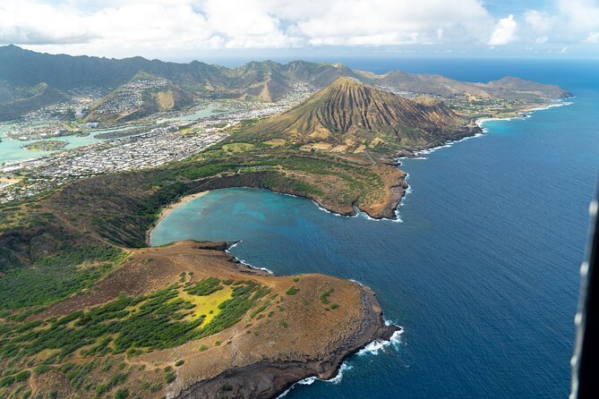
At $319 per person for roughly 30 minutes, this isn’t a bargain deal. But it can still feel like good value if you treat it as a one-time splurge and plan around how much you’ll actually see.
A few things help justify the price:
- You’re getting a small-group flight with pilot commentary, not just “ride and look.”
- The experience includes aviation headsets plus a cell phone lanyard, which is the kind of practical add-on that usually costs extra on other tours.
- You’re covering a lot of recognizable names in a short window: Honolulu Harbor, Ala Moana Beach Park, Waikiki, Diamond Head, Downtown Honolulu, Punchbowl, Moanalua Gardens, and major road corridors like H-3.
If your budget can stretch, it’s one of those “compress your bucket list” options. If your budget is tight, consider whether you’d rather spend on a longer guided island day on the ground. But if flying is on your list, this is built to deliver it fast and clean.
Getting to 1 Lagoon Dr: start point, what’s included, and what to bring
The tour starts and ends at 1 Lagoon Dr, Honolulu, HI 96819. You’ll return to that same meeting point at the end, which makes planning easier than tours that strand you somewhere else.
A couple of practical inclusions:
- Aviation headset for clearer communication in the cockpit area
- Cell phone lanyard to help you keep your phone secure while you take photos
You’ll also want to have your mobile ticket accessible on your phone. English is supported, and you’ll receive confirmation at the time of booking.
Two practical notes to keep you comfortable:
- There’s a maximum weight of 300 lbs per passenger, so double-check that before you book.
- The tour is listed as near public transportation, which can help if you’re not using a rental car.
The route that makes helicopter flying worth it: HNL to Waikiki and Diamond Head
Your flight takes off from HNL and starts laying down the Honolulu “map” immediately. One of the best parts of the itinerary is that it doesn’t only show coastlines—it shows the ways the city is built around them.
Here’s what stands out along the way:
Sand Island
You’ll see Sand Island early in the route. Even without stopping on the ground, it gives you that first aerial context: Oahu’s water edges aren’t a single continuous shoreline—they’re a patchwork of harbor zones, beaches, and man-made features.
Honolulu Harbor
Honolulu Harbor is the principal seaport of Honolulu and the state of Hawaiʻi. It’s also known by other names—Kulolia and Ke Awa O Kou—and seeing it from above helps you understand why ships and industry sit where they do. This is one of those spots where the helicopter view is more about structure than scenery.
Ala Moana Beach Park and Magic Island
Ala Moana is a free public park with a wide gold-sand beach over a half-mile long, sitting between Waikiki and downtown Honolulu. From the air, you can see the scale of that beachfront area and how it acts like a shoreline “bridge” between neighborhoods.
Next is Magic Island, a small man-made peninsula next to Ala Moana Beach Park and the Ala Wai Yacht Harbor. It was created in 1964 and later converted to a park, and the name was changed to Aina Moana but used less often. From above, you get a clear sense of how land was reshaped and repurposed.
Ala Wai Harbor and the Waikiki lineup
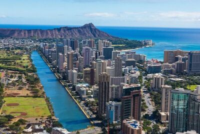
Ala Wai Harbor is described as the largest small boat and yacht harbor in Hawaii, located at the mouth of the Ala Wai Canal between Waikiki and downtown. From your seat, you’re effectively looking at the city’s watery gateway: boats, canals, and high-rise density all in one frame.
Then you’ll pass over Waikiki, with its high-rise hotels along the shore, the surf beach vibe, and the shopping stretch on Kalakaua Avenue. If you like seeing animals and sea life, Waikiki’s map points include the Honolulu Zoo (with Komodo dragons and wandering peacocks) and the Waikiki Aquarium reef exhibit. From the air, those are just labels—yet they’re useful labels because they connect what you know with where it is.
Diamond Head (Lēʻahi)
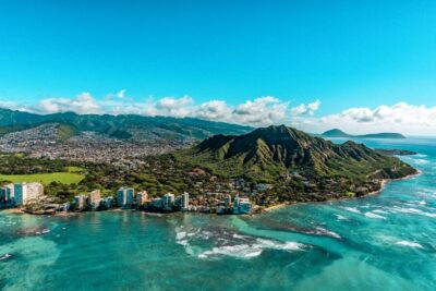
Diamond Head is a volcanic tuff cone called Lēʻahi in Hawaiian, and the Hawaiian name is linked to the idea that the ridgeline resembles a tuna’s dorsal fin. Seeing it from above gives you perspective on its shape and why it’s such a visual anchor for the city.
One downside here: a helicopter is fast. If you want museum-level time at each sight, this format won’t do that. But if your goal is to recognize Oahu’s highlights and walk away with a better mental picture, this segment delivers.
A few more Oahu tours to weigh up before you book:
- Private 60 Minutes Helicopter Tour in Honolulu
★ 5.0 · 91 reviews - Day Trip from Oahu to Hilo: Active Volcanoes & Helicopter Tour
★ 4.0 · 59 reviews - Blue Skies of Oahu Helicopter Tour
★ 5.0 · 50 reviews - 60 Minutes SHARED Helicopter Tour in Honolulu
★ 5.0 · 46 reviews - Complete Island Oahu Helicopter Tour
★ 4.5 · 35 reviews
Downtown Honolulu, Punchbowl, and the view that connects past and modern life
After Waikiki and Diamond Head, the route shifts toward downtown and memorial sites—an important balance from a pure “beach and skyline” flight.
Waialae Country Club
You’ll also see Waialae Country Club, a private club founded in 1927 and designed by Seth Raynor. The description includes a par 72 setup and specific yardage and ratings. From above, you’re not getting the full course layout experience like you would on foot, but you do get a look at how private land sits within the broader urban fabric.
Downtown Honolulu
Downtown here is described as Hawaii’s political and business hub, lined with skyscrapers. You’ll also pass over Iolani Palace, a restored 19th-century royal residence with original furnishings, and the Hawaii State Art Museum. Near the harbor, you’ll see Aloha Tower Marketplace, built around sea views from the 1920s Aloha Tower, plus its waterfront stage and restaurants. This is the part of the flight where the city feels like a capital city, not just a vacation strip.
Punchbowl Cemetery (National Memorial Cemetery of the Pacific)
Then comes Punchbowl, where the National Memorial Cemetery of the Pacific honors U.S. Armed Forces service members. From the air, the setting around Punchbowl Crater looks stark and intentional, which changes the tone of the flight from “fun views” to something more grounded.
This is also where the helicopter view is at its best: you see the location’s geometry and why it sits apart from the higher-energy beachfront zones.
Highways, tunnels, and Moanalua Gardens from the sky
The later part of the route shifts into infrastructure and quieter green spaces, which is exactly what makes a helicopter tour more than just a sightseeing slideshow.
H-3 Highway / John A. Burns Freeway
You’ll fly over Interstate H-3, also called the John A. Burns Freeway. The route description emphasizes that it crosses the Koʻolau Range via viaducts and through tunnels, including the much longer Tetsuo Harano Tunnels (5,165 feet) and the smaller Hospital Rock Tunnels. Seeing this from above helps you connect why Honolulu’s geography feels “layered”: neighborhoods aren’t just separated by distance; they’re separated by terrain.
There’s also a note that a section of the Moanalua Freeway between Route 99 (Kamehameha Highway) and the western H-1 interchange remains designated as Route 78. Even if you don’t memorize route numbers mid-flight, you’ll likely recognize how the road network threads through the island.
Moanalua Gardens and the Kamehameha V story
Next is Moanalua Gardens, a 24-acre privately owned public park. The description highlights the Kamehameha V Cottage, which used to be the home of Prince Lot Kapuāiwa, later King Kamehameha V. You’ll also pass over the site connected to the annual Prince Lot Hula Festival and a large monkeypod tree known in Japan as the Hitachi tree.
From above, the value is scale and placement. You can see it not as a “park you visit,” but as a defined green space with clear edges inside a city that otherwise spreads and fills most sightlines.
Aloha Stadium and the Halawa area
The route finishes with views toward Aloha Stadium in Halawa, described as the largest stadium in Hawaii. It also notes that as of December 2020 it ceased fan-attended operations indefinitely and placed a moratorium on scheduling new events. From the air, even without going inside, you get a clear look at how big that facility is—and how the island’s development surrounds big venues.
Photo tips that actually change what your pictures look like
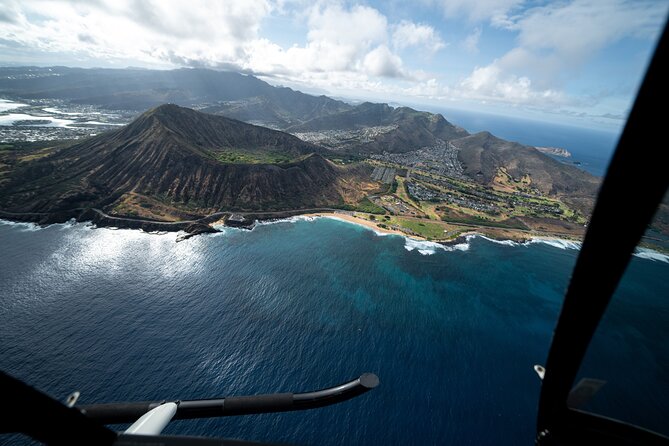
This is one of the few helicopter activities where the photography advice comes up again and again. The flight itself is short, so you don’t want to waste time doing things that don’t work.
A couple of practical pointers based on what the experience is known for:
- Take photos during stable stretches, not while you’re still figuring out where to point your phone. The route hits big landmarks in a predictable flow.
- If your operator allows it on your day, ask about door-off seating. One of the most common recommendations is to fly doors off for better photo angles.
- If the team provides help with photos (some flights do), keep an eye out right after landing about how you’ll receive them.
Also: don’t underestimate how much better it feels when you can see straight down onto coastline lines and harbor layouts. Helicopter photos are often more about clarity than “pretty haze.”
Pilot commentary, English, and who you might fly with
A huge part of making this tour feel worth it is the human layer. The tour is offered in English, and the pilot commentary is built to add context—so the names you hear aren’t random dots on a map.
The operator experience includes pilots such as Scott, Stefan, and Jacob. The names matter because it suggests consistency in staffing and a hands-on approach to guiding you through what’s below.
What I’d look for in a good flight: a pilot who keeps the commentary simple, connects what you see to a real landmark, and gives you time to look and shoot. In a 30-minute flight, pacing is everything.
Weather and day-of realities you should plan for
This activity requires good weather. That’s not small print you can ignore. Honolulu skies can shift, and helicopters don’t go out in every condition. If weather affects the flight, you’ll be offered a different date or a full refund.
Because of that, I recommend you pick this for a day with some flexibility. If you schedule it as your only free day and the weather turns, you don’t want to be stuck making tough calls.
Also, the tour is listed as “most travelers can participate,” but the weight limit of 300 lbs is firm, and it’s worth confirming that you’ll be within it before you book.
Who this helicopter tour suits best
This tour fits best if you:
- want a fast, memorable Honolulu overview
- like seeing how places connect—harbor to beach, Waikiki to Diamond Head, city to highways
- want a small-group setup with pilot narration
- value photos and aerial perspectives you can’t easily recreate from the ground
It may be less ideal if you’re after a slow-paced sightseeing day or if you’re traveling with tight time constraints and no flexibility. Also, if you’re hoping for lots of time on the ground, this isn’t that. This is a flight-first experience.
Should you book this Honolulu shared helicopter tour?
I’d book it if you want a high-impact Honolulu snapshot in about 30 minutes, and you can schedule it for a day with reliable weather. The route choice hits big, recognizable names—Honolulu Harbor, Ala Moana Beach Park, Waikiki, Diamond Head, Downtown Honolulu, Punchbowl, Moanalua Gardens, and H-3—so you leave with a clearer mental map of Oahu fast.
Skip it if $319 per person feels too steep for you, or if your schedule is inflexible. In that case, you might get more “time-on-your-feet” value with a ground tour.
FAQ
FAQ
How long is the helicopter tour?
The flight time is about 30 minutes.
Where does the tour start and end?
It starts at 1 Lagoon Dr, Honolulu, HI 96819, USA, and ends back at the same meeting point.
How many people are in the group?
This experience has a maximum of three travelers.
What is the price per person?
The price is $319.00 per person.
What’s included in the tour?
You get aviation headsets and a cell phone lanyard.
Is the tour offered in English?
Yes, the tour is offered in English.
What is the maximum weight per passenger?
The total weight per passenger limit is 300 lbs.
Do I need a paper ticket?
No. It includes a mobile ticket.
What areas can you see from above?
You’ll have a chance to see from above areas including Sand Island, Honolulu Harbor, Ala Moana Beach Park, Magic Island, Ala Wai Harbor, Waikiki, Diamond Head, Waialae Golf Course, Honolulu Downtown, Punch Bowl Cemetery, Moanalua Gardens, H-3 Highway, and Aloha Stadium.
What happens if weather is poor?
The tour requires good weather. If it’s canceled due to poor weather, you’ll be offered a different date or a full refund.
Is there a cancellation window?
Yes. You can cancel up to 24 hours in advance for a full refund. If you cancel within 24 hours of the start time, it is not refunded.
More Tours in Oahu





More Tour Reviews in Oahu


Oahu From the Air





Just Reviewed: More Oahu Tours



Helicopter & Air Tours, compared.
 ★ 5.0Magnum PI Hughes 500 4-Passenger Doors-Off HelicoptersFrom $4201,372 reviews
 ★ 4.9From Honolulu: Oahu 60min Helicopter Tour with Doors Off/OnFrom $540410 reviews
 ★ 4.9Helicopter Tour with Doors On or OffFrom $490221 reviews
 ★ 5.0Private Oʻahu Helicopter Experience: All Window SeatsFrom $415209 reviews
 ★ 5.0Path to Pali 30-Minute Doors On or Off Helicopter TourFrom $440104 reviews
 ★ 5.0Private 60 Minutes Helicopter Tour in HonoluluFrom $50991 reviews
Day Trip from Oahu to Hilo: Active Volcanoes & Helicopter TourFrom $98759 reviews
★ 5.0Private 60 Minutes Helicopter Tour in HonoluluFrom $50991 reviews
Day Trip from Oahu to Hilo: Active Volcanoes & Helicopter TourFrom $98759 reviews
 ★ 5.0Blue Skies of Oahu Helicopter TourFrom $43850 reviews
Where else this tour ranks